GPS scatterometry and reflectometry are regarded as valuable new techniques in the field of altimetry, oceanography and glaciography The high reflectivity of GPS signals in the frequency range of L-Band (1,2 and 1,6 GHz) on water, as well as iced and snow covered surfaces, partly compensates for the low signal intensity and allows the detection of reflected signal components.
Experiences with special Delay Mapping GPS Receivers in balloons and planes have demonstrated, that measurements of the sea level can be achieved with an accuracy of up to 5 cm. Only recently, has the extraction of altimetric height information of CHAMP occultation events been capable of being proven with a sensitivity in the decimetre range.
GFZ therefore suggests developing GPS occultation, reflectometry and scatterometry (GORS) receiver technology based on COTS, on the basis of a low flying mini-satellite constellation as a quintessential instrument for a future tsunami detection system. That is why the scientific and operation-specific demands on GPS altimetry measurements for satellite missions, as well as an architecture specific design concept, are to be developed. Furthermore, the ramifications for satellite missions, their operation and design, as well as for GPS receivers and antennas, must be evaluated to be able to design corresponding measures.
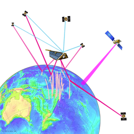
Reflection point tracks along the Indian Ocean within a space receiver scenario at a CHAMP orbit. The figures shows the receiver ground track (blue) and reflection point distributions for GPS (red), GLONASS (yellow) and GALILEO (orange). The reflection points that are furthest away from the receiver track have the lowest farthest apart from the receiver location have lowest angle of incidence. |
Within the context of GITEWS, a feasibility study is being performed on tsunami detection and warning from space using GNSS reflectometry (GNSS-R). GNSS-R uses existing signals from navigation satellite systems (Global Navigation Satellite Systems). GNSS signals that are reflected from the sea surface can be used for measuring the height of the sea surface and also allow conclusions to be drawn about the scattering properties of the sea surface for the purposes of scatterometry. GNSS-R receivers on low-flying satellite constellations can therefore be regarded as multistatic altimeters, which observe the sea surface at many reflection points simultaneously searching for tsunami wave signatures. A main topic of this feasibility study is the mission design for a GNSS-R receiver satellite constellation at a low orbit. Therefore, studies on scanning width and spatial resolution with respect to angle of incidence of the signals, the flight height of the receiver system and the type of GNSS system (GPS, GLONASS, GALILEO) have been conducted. They show, that the spatial resolution increases when signals of different GNSS systems can be received simultaneously and that the scanning width is highest for reflections at low angles of incidence. Another emphasis of the study is determining the altimetric precision that can be achieved. For this, simulations of the signal reflections are performed using a scattering model.
The JAVAD GeNeSiS-112 receiver board has a physical dimension of 112 x 100 x 14 mm and a weight of 110 g.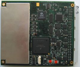 |
Within the context of the GITEWS project, the GFZ Potsdam, in cooperation with the German Aerospace Centre (DLR) and JAVAD GNSS, is developing innovative GNSS receivers for future satellite missions. The GORS receiver prototype consists of a JAVAD GeNeSiS-112 72-channel GNSS OEM receiver with raw data and position solution output. The processor can receive all presently available GNSS radio signals, including the new GPS L2C signals. For the first time, the specifically adapted receiver firmware allows dual-frequency phase measurements of reflected GPS signals with a civil signal code.
GeNeSiS-112 receiver with external (low noise amplifier) LNA in the signal simulator simulator test at DLR.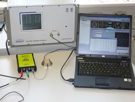 |
As part of the investigations regarding and space qualification of the JAVAD GeNeSiS-112 receiver, initial tests in a GPS signal simulator test have been conducted to assess the tracking and navigation capabilities under high signal dynamics. The tests demonstrate the capability of the GeNeSiS receiver to provide correct GPS measurements for orbit determination and scientific applications under the high signal dynamics of a user satellite in low orbit.
The phase time series, which are calculated from L1 C/A I,Q data (blue) and L2C I,Q data (magenta), on the left. Difference in path length between direct and reflected L1 C/A (blue) and L2C (magenta) signal, in the figure on the right.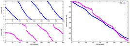 |
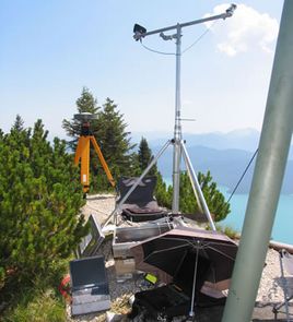
The experiment was - conducted on 17–19 July, 2007, 50 km south of Munich, Germany, in the Bavarian alpine upland at the mountain top of Fahrenberg (11.32°E, 47.61°N, 1625 m above sea level) with an unobstructed view to Lake Kochel and Lake Walchen. The reflections from Lake Kochel and Lake Walchen, which are situated 1026 m and 824 m, respectively below the Fahrenberg, were recorded. For the test, a conventional GPS patch antenna was mounted on a tripod and tilted by 45° from zenith direction to allow for direct and reflected GPS signal reception in parallel. Depending on the predicted reflection event, the tilted antenna was aligned toward Lake Kochel and toward Lake Walchen, respectively. During a reflection event, the master channel tracked the direct signal, while the slave channel recorded the reflected signal with a pre-set delay. The receiver records the I and Q vectors of the L1-C/A and L2C signal with a data rate of 200 Hz. From this, the difference in path length between direct and reflected signal was able to be calculated for both GPS carrier frequencies. From the changing path length difference, the altimetric height of the reflective sea surface was able to be calculated.
At the GITEWS Workshop "New Earth Observation Techniques for Tsunami Detection and Geohazards Monitoring", organised by LAPAN and DLR in Jakarta on 26-28 November 2007, first height profiles of Lake Walchen were presented. These show concurrences with tide gauge measurements within cm-accuracy. On this basis, it could be shown for the first time that dual-frequency phase measurements of reflected signals are possible.
Lake Walchen height profile on July 18 2007 12:54:51, calculated from reflected GPS L1 C/A (blue) and L2C (magenta) GPS signals for PRN No. 17.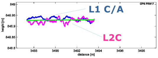 |
A. Helm, O. Montenbruck, J. Ashjaee, S. Yudanov, G. Beyerle, R. Stosius, and M. Rothacher, 2007: GORS - A GNSS Occultation, Reflectometry and Scatterometry Space Receiver, in: Proceedings of the 20th International Technical Meeting of the Satellite Division of The Institute of Navigation ION GNSS 2007, Fort Worth, Texas, Sept. 25–28, 2007, pp. 2011-2021
A. Helm, R. Stosius, O. Montenbruck, J. Asjaee, S. Yudanov,G. Beyerle, and M. Rothacher, 2007: The GITEWS GNSS Occultation, Reflectometry and Scatterometry Space Receiver GORS, presentation held at the GITEWS Workshop New Earth Observation Techniques for Tsunami Detection and Geohazards Monitoring, Jakarta, Nov. 26-28, 2007
|